
For those within New England, especially New Hampshire, have probably heard of the NH 48 Challenge. The word challenge may be interpreted however you wish, I for one, can say it’s a challenge for me. The list includes 48 mountains within the White Mountain National Forest all of which is greater than 4000 feet in elevation. Aside from the ability to say I have conquered the challenge, the hikes themselves are super rewarding. Each peak has it’s own spectacular view of the land beneath it.
I plan to make this a series of posts for you to follow the adventure and inspire you to take on the challenge! Accompanying me will be my friend Chris, whom was my roommate from College. At the end, we plan to send in our checklist to the Appalachian Mountain Club (AMC) and redeem it for an honorary patch for the success!
The posts format will include the time stamps for each portion of the trip to detail the distance vs. time relationship during the hike!
Mt. Whiteface and Mt. Passaconway (6:00 am)
The drive was about an 1.5 hours away from my apartment to the trail-head. The plan is wake up check my bag for a final time and head out to meet Chris at the Trail-head. The trail route we chose was an effort to chose the shortest measured distance all the way around. Later on, I’ll explain why that was not a good idea for us. Preparations were made the week before our hike and we planned our route and got our bags and gear ready. I recently received a new travel bag and wanted to put it to the test with some long hikes. I plan on continuing to use it and give a run down on the pros and cons about the bag. You can find the link here to find the bag. So far, I found the bag to be exceptional with the eye, it’s very sleek and stylish, but the question is, will it hold up?
8:00 am
Arrival at the Trail-head was a nice straight forward drive, nothing too hard to find. Chris arrived before I did, but we were able to start right at 8:00am, and our journey began. Chris had purchased a few hiking guides and mountain trail guides for our trips, which came in handy for us to plan our routes and figure out distances and times. The route was to follow Dicey’s Mill trail to Tom Wiggen’s trail, which connected to the Blueberry Ledge trail, bringing us to the top of Whiteface Mt.
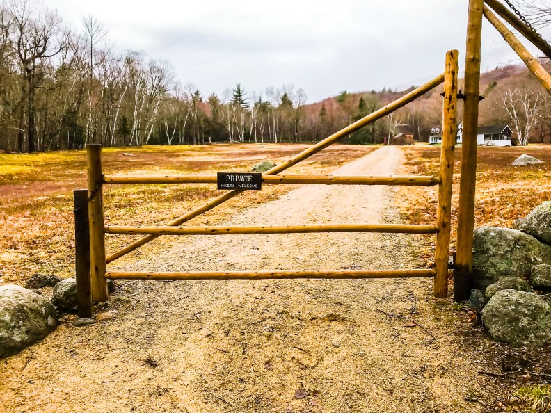
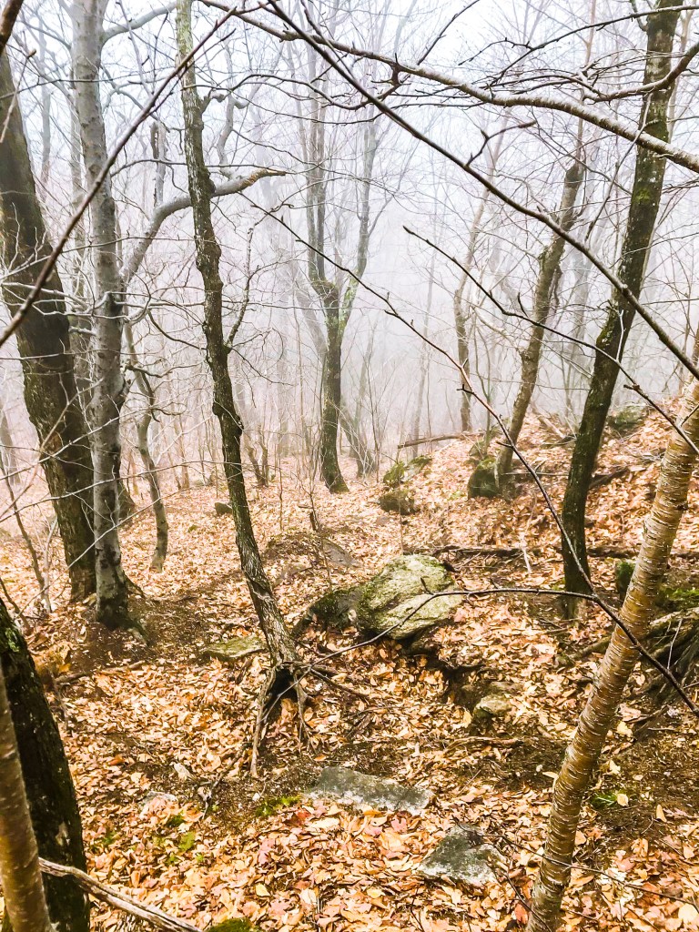
To start with Dicey’s Mill, you continue up the road from which you turn off of to park, and follow the road up to a gate. The gate is for private property but is welcome to hikers, don’t be hesitant on going through. The trail’s length is 1.9 miles to Tom Wiggen’s Trail. This trail is mostly flat, but has a few parts up and down.
9:08 am
The first 2 miles took us about an hour to complete and showed no challenge for us, it was comfortable and we held a good pace. Once we were on Tom Wiggen’s we started our ascent. The initial portion of the this trail was pretty easy still, mostly level walking and not too much elevation gain. The trail goes on for a few hundred feet winding around rocks while following the river that cuts through the bowl between the two peaks.
9:30 am
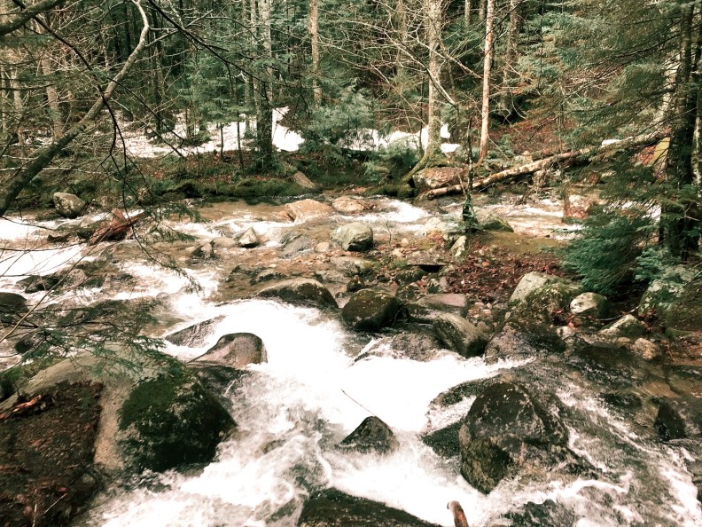
The first obstacle we encountered was the river that cuts through the valley. Not a deep or large river, but it does have fast moving currents There are places that are easier to cross compared to others, so make sure you stick to your own skill level. We managed to cross and a bit further up the river than the trail on the other side continued. The biggest factor was trying to stay as dry as we could.

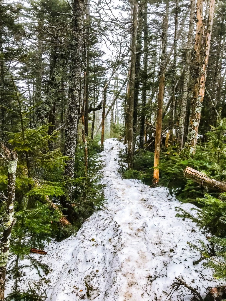
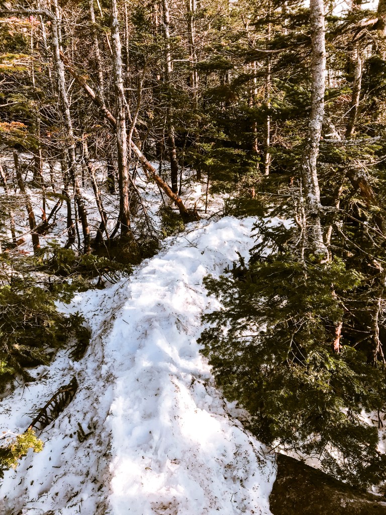
The Tom Wiggen’s trail was our attempt to reduce the overall mileage of the trip by half a mile, but in reality is probably added on an extra 2 hours of climbing. This is the part that I mentioned previously was a mistake. Trekking in the spring and winter seasons, the common trails develop what’s called a monorail, which just means repeatedly packed down snow in the same spot. Making it easier to climb during these seasons without trudging through snow. This trail had no such monorail…
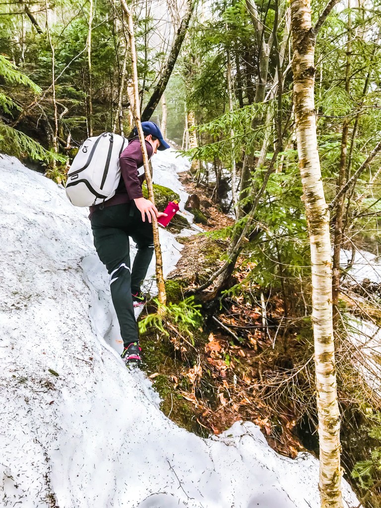
After about 45 minutes of climbing the trails rapidly increases the angle of inclination. At which we found snow. Yeah, snow… but not just any snow, deep, icy, wet, frustrating snow. This was not a common trail, and there was no monorail, instead Chris and I spent the next 2.5 hours climbing through waist deep snow. It wasn’t all waist deep, you would walk on top for a few steps then ultimately fall through… It was rough… blood had been drawn.
12:11 pm
LUNCH TIME! Which was highly deserved. Chris and I had finally made it to the trail crossing with the Blueberry Trail, where our new friend the monorail would be present. Chris and I found some stumps to sit down and take a quick break while we had our lunch. Pro Tip: Always bring spare socks, whether that is one or more pairs. I needed to change socks and luckily I thought about it and packed extra. We took about 15-25 minutes to gather our stamina back and digest a little before continuing.
About 30 minutes in we approached more actual climbing than hiking. For those interested in Whiteface Mt., you will need to climb up rocks and be fairly balanced when climbing. Don’t over pack your bags either, that could be the only between gravity helping you and taking you for a ride down a steep rock.
1:05 pm
We made it to the cliff view of Whiteface, which was incredible considering the conditions we had that morning. When we began at 8:00am there was still a heavy amount of fog around the area, which seemed to get thicker the higher we got. That was expected, but we were hoping that by midday the sun would have removed most of the fog. Even though the sights were gone, being up there was still amazing. We took some photos and videos regardless of the fog to capture this moment!
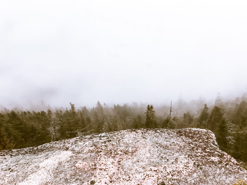
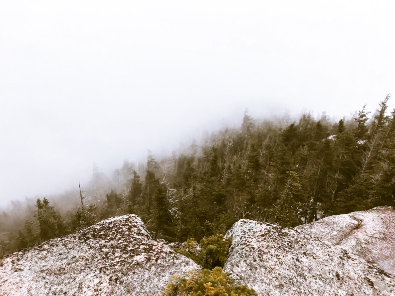


We continued the trail over the peak to the other side and begin our hike to the other mountain, Passaconway. Following the trail further across the peak, we found another open area for some great views, if it was a clear. At this point we didn’t bother too much in taking more photos of the fog haha, so we continued on.
2:04 pm
After some trekking, we made it to the next trail, Rollins Trail. This would bring us around the bowl between the two mountains, Whiteface and Passaconway, keeping us on the ridge line. Which I was very thankful for not having to descend and then ascend again. Now because of this trail, you can expect to take a good amount of time hiking. The trail is approximately 2.4 miles long. Not too bad in mid summer with good conditions, but the snow/monorail slowed us down quite a bit.
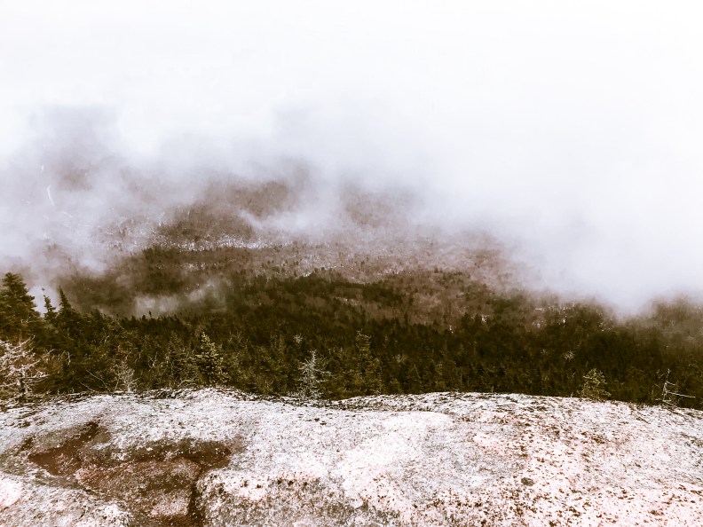
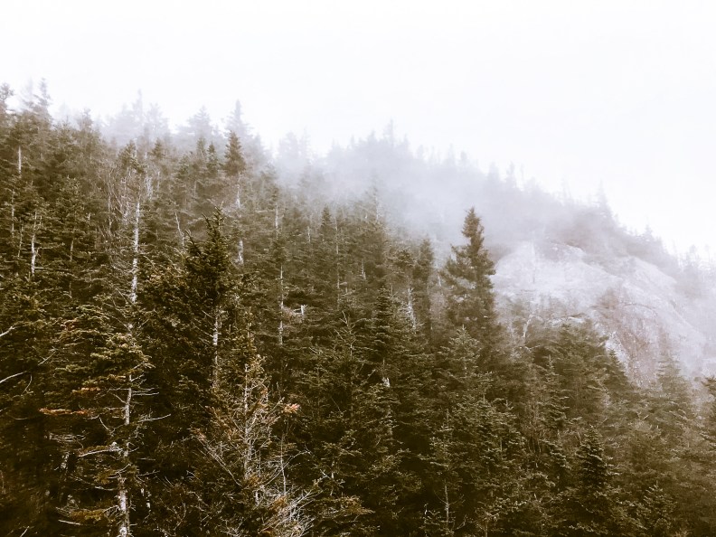
Every now and then we came across an opening on a ledge with some trees out of the way to observe out over the bowl. The first observation spot we made it to was really just below the fog line. Which made it perfect to see out over the bowl and see where Whiteface and Passaconway were in relation to each other. The fog was also still prominent over on Whiteface and the peak (where we were) was not visible at all.


5:08 pm
Finally 3 hours later, we made it to the other side of the bowl. Not an easy hike, but it was fun. The incline varied as we trekked over the ridge, and kept us at a pretty high elevation making the next ascent easier (emphasis on the easIER) The next portion of the trail was our way up to the peak of Passaconway, using the Dicey’s Mill trail. The summit was approximately 0.9 miles from this trail crossing with an elevation gain of about 800 feet. Using the monorail definitely made this climb easier, along with the switchback portion when it got steep. The switchback is a term that defines when a trail increases in elevation while zig-zagging left and right.
5:24 pm
Only about 20 minutes passed until we made it to the next trail change between Dicey’s Mill and East Loop. The East Loop is another loop that would ultimately bring us back down the mountain, so we continued the Dicey Mill trail to the summit. There are two trails that lead to the summit of Passaconway, the Dicey Mill Trail and the Walden Trail.
Following this ascent we passed through multiple small streams with open water, accessible without getting wet, and spent a good portion of the trail following the switchback. Trail guides estimate the ascent to summit from Dicey/Rollin’s junction to be about 50 minutes, which is also measured and estimated during better conditions during the summer. After about 45 minutes the switchback fades and a hike a more direct route. You will find that at this point the snow is mostly gone, making the use of the monorail more unstable.
6:09 pm
We finally made it to the Walden junction which indicates the general peak of the mountain. There aren’t too many view points for this mountain, only one descent view exists that we found just prior to reaching the Walden junction.
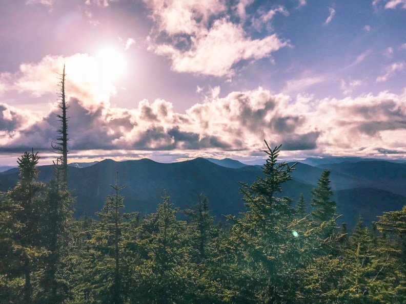

After some initial rest, we unloaded our bags from our backs and took a moment to savory the victory of the day. We were fortunate enough to reach the peak with sun still shining and a fairly clear sky too. The fog was completely gone in relation to our time at Whiteface. The way back down was a straight shot down the Dicey Mill trail all the way back to the trailhead. We snapped a few photos of success, refueled with some more snacks and began the descent.
6:30 pm
Most of the time you would assume the descent would be an easier job than the ascent. We assumed the same, regardless of using our own better judgement. The monorail was present for the majority of this trail down, which was mostly the reason for this not being a smooth way down.
Even though the snow was packed down for hiking, climbing down was like trying to ice skate in slush. Once we were back on the switchback it was much more stable and easy to climb down. This was when we started to talk about the distance and our sun light left. The sun was suppose to set around 7:45 pm giving us just about an hour to make it a little under 4 miles. Yeah, not so good for us. We knew we were going to be in the dark for a portion of the trip down, we just wanted to make that portion a tiny as possible.
7:15 pm
With about 15 minutes before actual sunset, we made it back to the East Loop junction, meaning it took us the exact same amount of time going up as going down. Not so assuring for the remain trip down. However, this was a new trail and we had no idea on what the conditions would be like. The only thing that was more certain was the condition of the Dicey Mill trail would be much more favorable than the Tom Wiggins trail. As we continued we stayed positive and just kept moving.
7:25 pm
Finally, some speed was developing. At this point we made it back to the Rollins trail junction which cost us 16 minutes to hike up but only 10 to hike down. It wasn’t a large change, but given the snow, energy, and distance we were happy to start shaving off some of the time. The long descend officially began at this point.
8:18 pm
The sun had finally set, the after glow off the horizon was slowly diminishing and we had to resort to our flashlights. We came prepared with head lamps, and multiple flashlights (lots of fresh batteries too!). Being prepared was our biggest priority when planning out our trips. We began to make out a checklist for our bags, and go by it as a rule of thumb and any extra gear would be directly related to the current forecast and conditions of the last trail report. With the help of all the wonderful people that love the outdoors, you can access a constant update to the trail conditions in reference to each peak. Using the link here you can search for the mountain of interest and find all you need to know about the conditions before the hike. (UPDATES ARE NOT DAILY, be sure to keep updated as your hike nears its date).
About 15 minutes prior to the need of our flashlights we were out of the snow, which was fantastic, because the snow was hard to climb in the day light.
The only time stamp we didn’t record was the other river crossing we had to make. Unlike the previous crossing we were now in the dark, what made it slightly easier was there was no need to search for ways not to get wet. I said slightly easier because we were in the dark and needed to cross a 30 foot log over 4 feet of water. Yes, we were both already soggy, but I wanted no part in being any wetter than I was. Thankfully this was a rather routine passage for hiking this trail, so this fallen tree was rather flat and plenty wide to walk across.
8:45 pm
Tom Wiggins trail junction was met indicating that we were 1.9 miles away from the start of the trail. Sadly this was only the start of the actual trail we still had about 15 minutes on the road to the parking lot.
The final stretch was mostly flat, and we were at the bottom of the bowl between each of the mountains. Without sounding like death was upon us, our movements were rather sluggish and that last stretch took way longer than needed. The pace was slowing down and we were itching to get back.
A few detours were made unnecessarily, as we went some ways without finding a trail blazer. A challenge with this trail was most of the blazers (tree markings) were either placed on rocks (which would have been fine during the day) and on bark that was no longer on the tree it once was on. We realized this when we were following a familiar stream and getting our feet now not only soggy but muddy too, that the trail was about 20-30 feet to our right.
9:54 pm
WE MADE IT! What a day, and an incredible challenge for us to do. Our first hike of the summer was definitely an over ambitious one, but we made it and got to check off 2 of the 48 peaks. Yes, we were really tired, hungry, and still soggy. Chris brought sandals to drive home in, I did not… but that sums up our first adventure in the White Mountains, next week will be Mt. Tecumseh. A much shorter hike in comparison.
Lastly, I would like to point out that even though it was one hike in, the backpack previously mentioned, held up tremendously. It was comfortable and fit well on my back and shoulders. The only con, was it needed a sternum strap, however you can buy one of those for a few bucks and attach it on. Again I can leave the link here and if you are interested, you can save 15% on the bag using our personal code!
“training4tomorrow” for the 15% off
What we Learned?
- Don’t over pack your bag
- Always bring enough food and water (we needed more snacks)
- Make sure the food you bring is sufficient to keep you hiking
- Always bring flashlights (with extra batteries)
- Chose your gear carefully for the conditions of the hike
- Expect the conditions to change
- Bring a change of clothes or at least socks (more than one pair)
- And do better research on the trails (due to Tom Wiggins trail)
Each week I intend on keeping you all up to date, with each hike. So be sure to sign up for our blog subscription below:
If you would like to stay updated with more travel deals including gear promotions and budget destinations, join our travel family below!


One Reply to “New Hampshire 48 (Week 1)”